The Englewood Dam was built by the Miami Conservancy District after the Great Flood of 1913 along with four other dams (Taylorsville, Huffman, German Town, and Lockington). It is now a part of the Five Rivers Metro Park System.


MCD SYSTEM
Englewood Dam
Photo: Ryan Hulvat

Englewood Dam is an earthen embankment located across the Stillwater River in northern Montgomery County near the City of Englewood. U.S. 40 goes across the top of the dam. Construction of the dam began in February of 1918 and was completed in December of 1921.  

The dam has two concrete conduits through the base of the embankment near the center of the valley. The conduits are sized to discharge floodwater at a rate that can be handled by the flood protection levees and channels downstream. The remainder of the floodwaters are temporarily stored behind the dam and released over time. An emergency spillway is located in the right abutment at the west end of the dam. 

Englewood Dam Statistics

  • 4,716 feet long
  • 110.5 feet high
  • 739 feet wide at dam base
  • 3.5 million cubic yards of earth in the embankment
  • Two concrete conduits
  • Each conduit is 709 feet long, 10.5 feet high and 13 feet wide
  • The spillway is 100 feet long
  • Volume of concrete in the conduits is 66,800 yards
  • Drainage area above Englewood Dam is 651 square miles

Elevation and Hydraulic Information

  • Elevation of the dam is 892.5 feet above sea level
  • Peak elevation Probable Maximum Flood is 888 feet above sea level
  • Spillway elevation is 876 feet above sea level
  • Peak Elevation Official Plan Flood (OPF) is 873 feet above sea level
  • Elevation where storage begins is 783.5 feet above sea level
  • Peak discharge for OPF is 12,000 cubic feet per second
  • Time to empty the storage area after an Official Plan Flood is 28 days
  • Water stored to the spillway would inundate 7,930 acres of land upstream from Englewood Dam. The 312,000 acre-feet of water would extend along the Stillwater River 23 miles to Bridge Street in Covington, Miami County.
Englewood, founded as Harrisburg, was not laid out until 1841, but the Rasors, Herrs, Gishes, and Stutzmans had purchased lands upon which the town was built in the early 1800s.  The building of the National Road put Englewood on the map and construction of hotels and other businesses to accommodate travelers helped the town to grow.  Both the D.C. &T. narrow gauge railroad and D.C.&P. Traction Line, which ran along the Dayton-Covington Pike, went through town.  Construction of Englewood Dam and later the proximity of the town to the Dayton Airport, Interstate 70, and Englewood Reserve has enabled the city to grow and attract industries.


Some time after 1869 the Burlington, Delphos and Toledo Railway Company built a narrow gage line through Randolph Twp.(soon after became C. H. & D) The RR made sure that the Kinsey Nursery would have a freight station to facilitate the shipping of the thousands of trees and vines each year. The Kinsey Station was located on the north side of what is now Kinsey Rd.  It was located one tenth of a mile West of  Taywood Rd. on the North side. Today the power lines follows the old RR right a way.


This Covered  Bridge carried the traffic of the National Rd. over the Stillwater River until the National Rd. was re-routed over the Englewood Dam in 1922
   
 
  Looking East over the National Rd. and the C.H.& D. RR tracks. The Berger Lumber Co. on the left.
   
 
  Looking at the S.E. corner of the National Rd and  Main St. (Covington Pike)
   
  Englewood
  Inter-urban traction approaches from South at intersection of 40 and 48.
   
1926 aerial photos for Englewood were taken by William Mayfield. William took aerial photos of forty-six local towns and cities in conjunction with Rike- Kumler's 73rd anniversary celebration.


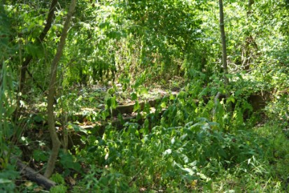
 There are several stories associated with Englewood Dam. The first is from an over the road truck driver. He claims to have seen a glowing faced driver behind the wheel of a black, non descript, vintage sedan. The sedan was said to have nearly forced the truck driver to wreck into the guardrail. When the truck driver hopped out of his cab to get a look at who had done this, the vehicle was gone. The only thing that he could remember was the ghastly glowing face. 

Below is the campsite at Englewood Dam named after the Patty family.

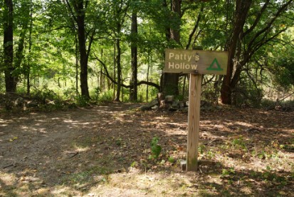
Another encounter with the other side is said to be of a young lady dressed in white. She has been seen floating along the trail on the West side of the bridge. Many have attempted to follow and catch this spectral lass, but no one has yet.

Pictured below is part of the foundation of the Patty Home.

In 1869 the Patty family moved to Ohio and had become the caretakers of the covered bridge that connected Vandalia and Englewood. Mr. John Patty had two daughters. There are several takes on how the ghosts of these two daughters became permanent residents of the Englewood Dam and Metropark.

The tales all end the same. The sisters are found dead hanging in a large nearby tree. But how did it happen? Which story is the most accurate?

It was a dark and stormy night. Mr. Patty is making  his way home. Just as he nears his homestead, a series of shrieks and moans fill the chilled night air. Arriving near his spring house, his eyes fill with fright as the lightning flashes across the sky. His daughters are dead. Their bodies sway with the wind like buoys on the ocean. Who murdered the sisters? Some say a drifter who not only murdered the sisters, but also slaughtered the family horses.

Another tale paints a new picture of the same sinister acts of murder. But not by a drifter. But by the father himself. As Mr. Patty arrives at his home, he finds that his daughters have broken the most sacred rule one time too many. The sisters were very pretty and were sought after by many gentleman suiters. Mr. Patty had told the girls not to have anyone over without a chaperone. Time and again the father would find his daughters in the company of suiters that he did not agree with. This was the last time. If the sisters did not agree with his rules, then they would pay the ultimate price.


In a nearby Quaker Cemetery, there are a pair of headstones that belong to two sisters with matching last names. They both died in the same year and are in the Patty family lot.

When the time is right, it's said that you can hear the same shrieks and moans.

Above is the original Spring House that the Patty family used for their fresh water supply as well as for storing provisions. Below is the supposed hanging tree that the Patty sisters were hung from.

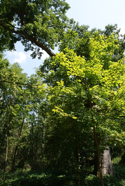
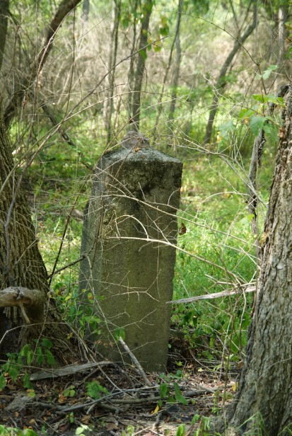
This type of column was typically used to mark where one persons property ends and where another begins. This one is made of limestone.

 
Make a Free Website with Yola.